Extension Features
There are several additional requirements that are addressed by the extension.
Localization
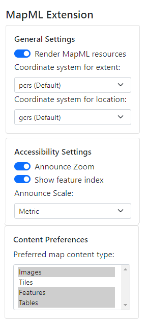
By default, the extension uses the browser's locale to display any <mapml-viewer> UI in the user's locale. Note that if the UI is not localized to your browser's language, it is likely because there currently exists no translation of the UI strings for your locale. Localization contributions are welcome. Languages that are available at the time of writing are english, french and swedish.
Feature Indexing
When turned on through the extension, enables a square in the middle of the map to enable a keyboard index menu of features located inside the square.
Announce Zoom Level
When toggled through the extension, announces the zoom level through screen readers (this is on by default).
Announce Scale
Announces the map scale through screen readers in metric or imperial units (metric is selected by default).
Render MapML resources
When turned on through the extension popup (it is on by default as shown above, but can be turned off), the extension enables the rendering of map documents that have no host document, just as browsers can render image resources (image/*) that have no host document, by synthesizing a host document at run time. The feature will recognize documents that are served to a browser tab (a top level browsing context) that are served with the "text/mapml" or "application/xml" Content-Type header. In the latter case, the extension will "sniff" for a root <mapml- xmlns="http://www.w3.org/1999/xhtml"> element.
Set a coordinate system for copy operations
By default, the coordinate system (cs) for copying the map extent using the map context menu is projected coordinates (PCRS), and that for copying locations is by default geodetic (GCRS). When changed to another through the extension user interface, the selected cs will be used for subsequent copy operations.
Select map content preferences
By default, no preference is expressed by the user as to what their preferred content type for maps may be. Some users may prefer focusable feature data in the map where possible; others may opt for image-based or tiled-image based map content. Others may wish to experience only textual feature data in the form of an accessibility technology (AT)-friendly table that is by default sorted in ascending order of distance from map center, but that may be sorted by different column headings selected by the user. To establish a set of preferences, select the applicable combination of entries from the "Content Preferences" list (select more than one entry by holding Ctrl or Shift while selecting).
Such preferences may be honoured by a map author via inclusion in map 'media' queries.
Requirements
Report problems with these requirements on GitHub
requirement enhancement impractical undecided under discussion
| Spec | Viewer | API | |
|---|---|---|---|
| The GeoWeb - proposed Epic | |||
| full | full | ||
| Client-side Mapping API Capabilities (6.0) | |||
| full | full |